 How it Works
 Hansadrone solves the "final 50 feet" problem of drone delivery: How to fly the drone from cruising altitude to the customer. In many cases, there is no landing location and the customer's location is not exactly known.
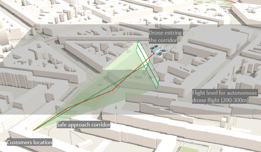
The Hansadrone service defines an approach corridor that is safe to use and that tolerates large deviations of the customers location in the first place.
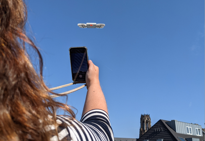
Optical recognition is used, with an app installed on the customer's smartphone, to recognize the actual position of the drone and compare this to the previously defined safe corridor. From that, deviations are calculated and provided to the drone to correct it's position as it approaches through the corridor.
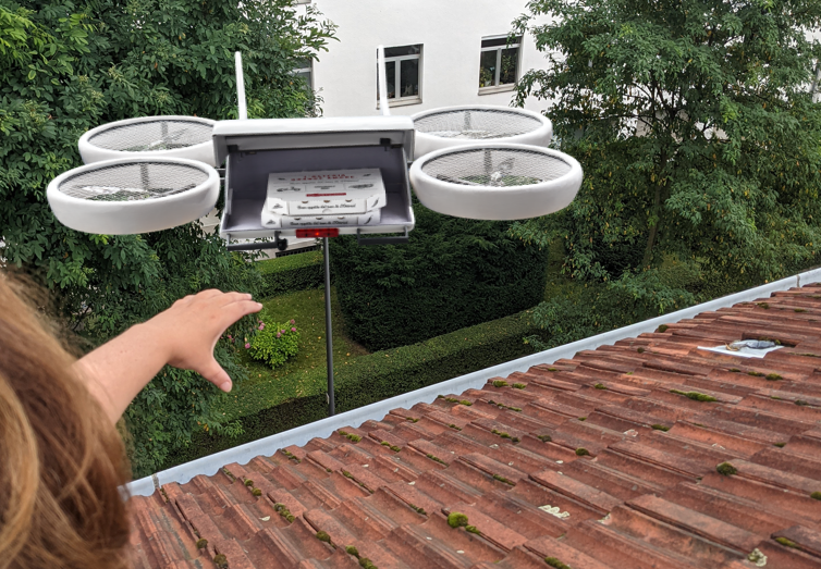
This solution allows to make deliveries to any location even if there is no place to land. At customer side, no markers, homing beacons packeage receptable boxes are needed. All he needs is an app installed on his smartphone and a place with a clear view towards the sky.
Precision Navigation The location of the customer is usually only known with an accuracy of up to +/-5 meters in the best case if a GPS signal is available. Or even less at +/- a couple of 10's of meters in case of a cell based positioning. This is by far not precise enough to make a delivery approach towards a window or balcony.
The Hansadrone final 50 feet approach solution solves this problem by defining a wide corridor, which tolerates large deviations both on absolute distance as well as on the angle and will provide corrective commands for the drone to adjust its position as it approaches the customer.
The drone will iterate a couple of times as it flies through the corridor. In the end, it will hover right in front of the customer’s smartphone camera within a precision of typically +/- 10 cm. Drone, app, backend and drone flight management software make up a closed loop control cycle. The solution is fraud safe: The drone will send out a coded light signal to uniquely identify the drone in real time.
 Safety First
 Safety is of most concern with any flying object.
This not only includes the risk of a drone crashing or colliding with other flying objects. The final 50 feet are in particular sensitive as the drone is getting close to built-up areas and near people. The Hansadrone solution offers a unique way to define and validate a safe corridor for the drone to descend into lower airspace and come close to the customer.
It also allows to have the entire approach flight being monitored by the camera of the customer's smartphone. This video stream, next to an image of the define corridor, is recorded and stored on the cloud backend. This data is used for real-time image analyis using AI to identify any obstacles in the flight path.
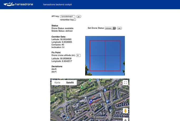
In case of an incident, the stored data can be used for clarification later if needed. All data stored on the cloud backend and can be accessed over an API or via the dashboard.
Privacy Privacy is a big concern to the public. Drones will only get acceptance if they are not only safe but also respect privacy when flying at rather low altitude over built-up areas. Cameras are of utmost concern to residents. Even if the video signal is not transmitted but only used onboard the drone, this will hardly be accepted.
With the Hansadrone solution, the drone does need to have a camera to identify obstacles or to spot a landing zone. Instead, the camera of the customer is used to identify a safe approach corridor which is free of obstacles. The customer has to point his camera to the sky, which is not causing any legal or privacy issues.
The defined corridor allows the drone to approach the customer very fast, reducing the overall time that the drone spends in lower airspace. The drone will not hover in the air while roping down its payload. This, in combination with ducted fans, will drastically reduce the noise level and overall footprint during the delivery. The approach and unloading will take just a few seconds and will hardly be recognized by neighbors.
 Data Integration
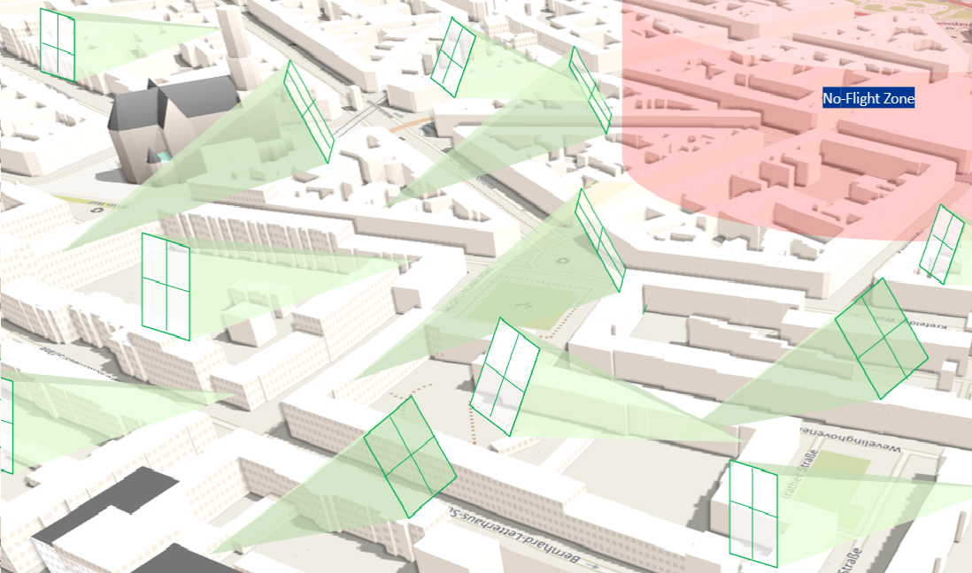
 The defined approach corridor is a spatially stable 3D object that looks like an upside-down pyramide, touching the customers location with the pointy end. This 3D object can be validated against other 3D data like 3D building data, no-flight zones, power lines or other delivery corridors that are in use at the same time.
A second source of validation is real-time AI image recognition. It is performed directly on the mobile device app for lowest latency and works even with no internet connection. The image recognition will identify any non-sky object like a building, a tree, a power line or another flying object.
But it doesnt stop here: The sky is contineously being monitored throughout the entire approach flight. The drone will stop immediateley if any obstacle is recognized or if the smartphone camera is no longer pointed at the corridor.
Over time, the combined data of defined corridors aggregates into a detailed data model of the lower airspace, not covered by any other data set so far.
Low Market Entry HurdlesThe Hansadrone solution has the lowest market entry hurdles of any drone delivery platform: It does not need any special marked landing zones at the customer's site or homing beacons to guide the drone.
It also dones not need landing platforms attached to each window to serve customers who live in an apartment building. With the Hansadrone service, any customer can directly be servced, no matter where he lives.
We provide an SDK that can easily be integrated to your app, no matter if you are delivering packages, groceries, food or medicine.
All that is needed at the customer's end is a smartphone with the app installed - and of course an open window!